 Beaver forest (No. 2 on the map) from the previous page is accessible from the river by dozens
of trails used by beavers to pull parts of the cut down trees into the river. On the map these trails
are represented by short lines leading from the river into the forest (I have not counted the
trails, there is even more of them in reality than on the map). The best time to see them from a distance
is after the first snowfall bringing preferably at least 10 cm of snow, which is not yet visible in the tall grass
but which already covers well the trampled grass or the muddy surface of the beaver trails.
These are then visible from afar as white ribbons on the background of yellow-turned grass.
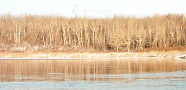
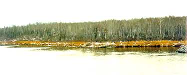
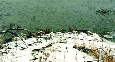
I have tried to show this on the first three pictures on this page. The first one above
of Nov. 17 shows the whole river bank from the bridge almost up to point No. 1 - that dark
spot near the middle is a granite rock sticking out into the river as shown on the map, which in
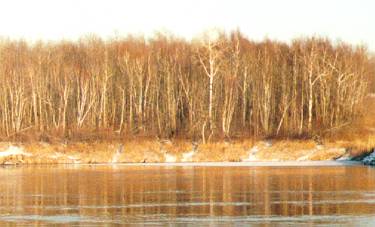
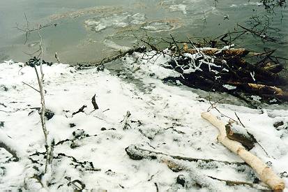
the summer is a favourite spot of a few anglers. Below are the enlarged cut-outs of two photos of
Dec. 7, when we had a bit more of the "first" snow than in November. On the right is the region
between the bridge and the granite rock, and on the left is the area just north of the rock.
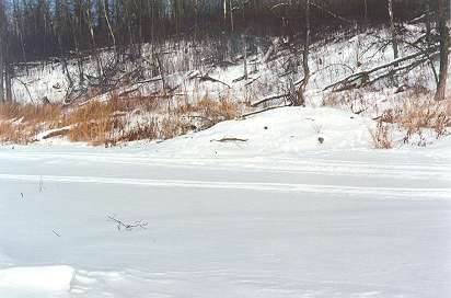
You can see there one beaver trail after another. Later in the winter everywhere there can easily
be around half a meter of snow which will cover with some help from the wind even one meter high grass,
and everything will be completely white.
Beaver forest (No. 2 on the map) from the previous page is accessible from the river by dozens
of trails used by beavers to pull parts of the cut down trees into the river. On the map these trails
are represented by short lines leading from the river into the forest (I have not counted the
trails, there is even more of them in reality than on the map). The best time to see them from a distance
is after the first snowfall bringing preferably at least 10 cm of snow, which is not yet visible in the tall grass
but which already covers well the trampled grass or the muddy surface of the beaver trails.
These are then visible from afar as white ribbons on the background of yellow-turned grass.
I have tried to show this on the first three pictures on this page. The first one above
of Nov. 17 shows the whole river bank from the bridge almost up to point No. 1 - that dark
spot near the middle is a granite rock sticking out into the river as shown on the map, which in
the summer is a favourite spot of a few anglers. Below are the enlarged cut-outs of two photos of
Dec. 7, when we had a bit more of the "first" snow than in November. On the right is the region
between the bridge and the granite rock, and on the left is the area just north of the rock.
You can see there one beaver trail after another. Later in the winter everywhere there can easily
be around half a meter of snow which will cover with some help from the wind even one meter high grass,
and everything will be completely white.
|
|
|
|---|
 And the lodge of our beavers can finally be seen on this photo of Nov. 17. It is that rather
inconspicuous dark pile of mud and wooden logs in the middle of the right-hand side of
the picture. It blends quite well into the rest of the river bank and only somewhat protrudes into
the river. On the map, the position of this beaver lodge is denoted by the black oval near No. 1.
On both sides of the lodge there are little "bays" in which two of the above mentioned tunnels leading into the forest start.
And the lodge of our beavers can finally be seen on this photo of Nov. 17. It is that rather
inconspicuous dark pile of mud and wooden logs in the middle of the right-hand side of
the picture. It blends quite well into the rest of the river bank and only somewhat protrudes into
the river. On the map, the position of this beaver lodge is denoted by the black oval near No. 1.
On both sides of the lodge there are little "bays" in which two of the above mentioned tunnels leading into the forest start.
The ends of the branches sticking out from water in front of the lodge on the left-hand side of the picture represent only a small tip of the underwater stockpile prepared by the inhabitants of the lodge for the winter. Beavers spend all the winter inside their lodge, the inner chamber of which lies above the water level but is accessible only through several entrances leading through the water. Beavers do not hibernate. They feed all the winter on the bark of trees they harvested in the fall. They swim under the ice to their stockpiles, and bring into their lodges tree branches and logs to feed on.
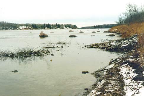
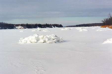
In the background of this picture one can see another esthetically appealing group of granite
boulders sticking out from the river - the largest of them are a few meters in diameter
(see at the end of this page on how they looked later this winter).
|
This is the view of the lodge from the slope above it, taken on Dec. 8. The distance from where the lodge disappears under the water to its highest point is almost 10 m, though it may not seem that big from this picture. In the water in front of the lodge you can see faint outlines of tree trunks stored there by our beavers. |
|---|
| Then I descended almost to the water edge, and took this picture showing a close-up of the part of the outer surface of the lodge that was partially hidden on the previous picture behind the big branch near the left edge of the photo. You can see two beaver trails beaten into the snow, leading from the water onto the "roof" of the lodge, and a white-gnawed log. Comparing both pictures (what is on the second one takes only a small part of the first one) can give some idea about the size of the lodge. (Dec. 8) |
|
|---|
It seems that beavers concentrate their logging every year into a different area. In the past, they cut a lot of trees north of their lodge, where I have not found a single fresh beaver stump this year. North of the bridge, they had already harvested most of the tasty aspen trees within those 30 m from the river in previous years, and that is probably why they turned this year so much attention to that little grove near the Pinawa Bridge Wayside, from where it is at least 250 m to their lodge. As it is down the river, it may actually not be that difficult for them to transport logs back home, and they may continue to expand their logging area southwards before new aspen trees will grow closer to their lodge. Beyond those 30 to 50 m there remains a lot of aspen trees also near their lodge, but apparently they are afraid to go that far from the river.
|
This is the view of the lodge from the frozen river on Jan. 25, 1999. You can see snowmobile tracks passing directly over the beaver castle. Poor beavers inside must have been frightened by the roar of the snowmobile engine! You can still see a few tips of the branches from the beaver stockpile protruding through the ice and snow, indicating that this winter there is much less snow and thinner ice than usual. |
|---|
| The ice-capped rocks just north of the beaver lodge. These piles of fast frozen ice accumulated around the rocks during a sudden deep freeze in December. This is the first year that such formations appeared here, and around all the other rocks in the river. |
|
|---|