Granite rocks, beavers, and other sights
near
the Pinawa bridge on Winnipeg River, Manitoba, Canada
Miroslav Kolar, Nov. 1998 - Jan. 1999
What you will find here: The first four pages after this introduction show some nice groups of rocks near the bridge, their comparison with a famous rock garden in Japan, and the interaction of light, waves and rocks. Then follow five pages on the beavers living near the bridge - on how they prepare for the winter, cut trees and transport them to their lodge. After that comes one page about beavers living on creeks, and a page on muskrats from around the bridge. Then follows a winter page with really nice pictures. Last two pages are quite short - a page on geese who did not hurry south followed by a page about the nearest dam on the Winnipeg River. These 15 pages contain 76 different photos of mine (© Miroslav Kolar), and the Ryoanji window will show 3 more from other sources. I hope they will all load reasonably fast.
A sketch of a map of the place that this essay talks about was supposed to appear in a separate window (if it hasn't, enable JavaScript or try to click on Show map in the menu on the right; if none of that helped, click here). I am afraid that I have failed to draw all the details in the map in a proper scale. For example, the width of the Winnipeg River at the bridge is about 320 m, whereas the distance between points 1 and 3 is only about 250 m.
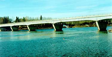
In the first picture above is a view of the bridge from point 3 in the map. The bridge carries across the river the only highway leading into Pinawa, which ends there (a picture of the first car that crossed this bridge can be found on the Pinawa history page).
Although many photos that you (will) see here suggest that the river surface is almost motionless, the current of the Winnipeg River is quite strong in this place. The river flows north where it empties into the vast Lake Winnipeg, whose shores remind me in some places of the Baltic Sea of Europe. But before reaching the Lake, Winnipeg River has to first overcome a distance of about 70 km along which its progress is slowed down by a cascade of three dams with hydroelectric generating stations. South of the bridge, one can see in the distance of about 2 to 4 kilometers the building of another hydro station sitting on the top of the Seven Sisters Falls dam (see the last page). Before the dam was built there, dangerous rapids in that place were posing a serious obstacle to the first fur traders who started to come to this region in the early 19th century in their birch bark canoes from the far-away Montreal, until they found another, smaller arm of the Winnipeg River - the Pinawa Channel - just east of the present-day Pinawa. Further upstream there are two more dams with hydro generating stations.
Seemingly never ending deep forests of the Canadian Shield start on the eastern bank of the river (green colour). They go on from here for thousands of kilometers through the Northern Ontario and Quebec as far as the Atlantic. One can find a lot of rivers, lakes and wild animals in these forests, and only occasionally an isolated community. The Canadian Shield is a huge plate of granite, several kilometers thick, which in many places in those woods, lakes and rivers sticks out above the ground or water as rock outcrops, boulders and islands, usually of smooth surface and pinkish in colour. On my map, such granite formations found in the river around the Pinawa bridge are represented by those greyish pink blobs.
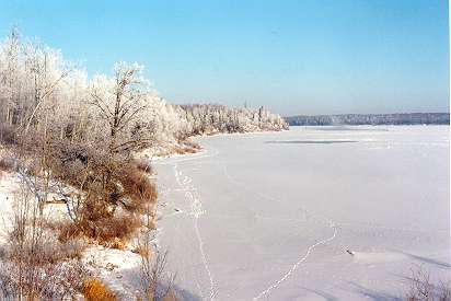 On the western bank (shown here in the winter, with wildlife trails in the snow on
the ice along the bank) of the Winnipeg River, in the vicinity of the Pinawa bridge there
is only a relatively narrow band of trees, hiding a row of family houses and farms
with a nice view of the river. Further to the west, within the distance of about 50 kilometers
from the river, there are still islands of forests among which the open prairie (nowadays
almost completely utilized for agriculture) starts, stretching for about 1300 km
across Manitoba, Saskatchewan and Alberta to the foothills of the Rocky Mountains.
And about 100 km west from here in Winnipeg, the capital of Manitoba, already in the
middle of the prairie, lying on another big river, on the Red River, which also
flows north into the Lake Winnipeg.
On the western bank (shown here in the winter, with wildlife trails in the snow on
the ice along the bank) of the Winnipeg River, in the vicinity of the Pinawa bridge there
is only a relatively narrow band of trees, hiding a row of family houses and farms
with a nice view of the river. Further to the west, within the distance of about 50 kilometers
from the river, there are still islands of forests among which the open prairie (nowadays
almost completely utilized for agriculture) starts, stretching for about 1300 km
across Manitoba, Saskatchewan and Alberta to the foothills of the Rocky Mountains.
And about 100 km west from here in Winnipeg, the capital of Manitoba, already in the
middle of the prairie, lying on another big river, on the Red River, which also
flows north into the Lake Winnipeg.
It is quite possible that most of the people hurrying across this bridge in the hustle of everyday life do not realize how nice the place actually is. Of course, in the vast space of the Canadian Shield there must certainly be many places much farther from the civilization, which are even more beautiful, where the nature is more intact, and where the granite is more pink. But the Pinawa bridge is just a few kilometers from my workplace, and so I can follow on a daily basis what's new there, while being able to do a relatively high tech job. When I came here almost six years ago to take up this job, I was spoiled by the spectacular beauty of the Rocky Mountains in the relative proximity of which I spent my previous years in Canada. At first, everything seemed to me too flat, monotonous, and not very interesting around here. But then I realized, that with a little bit patience, one can find beauty everywhere. And beauty helps make life easier.
A very nice view of the area south of the bridge is from point No. 4 in the map, where there is quite high above the river a small rest area (Pinawa Bridge Wayside) with toilets, boat launch (No. 5) and a fire pit near the river at No. 3. This place is taken care of by the Manitoba Provincial Parks crews in the summer, which is why you can see a maintained lawn on the pictures taken up there. On the other hand, just north of the bridge, one can find a typical natural Canadian forest, difficult to walk through, only a narrow strip of which along the river is managed by beavers, who will be the centre of our attention in a while. At night, one can have from there nice view of the awesome displays of the northern lights in the sky, and count the falling stars (it seems to me that there is at least one per hour most of the time).
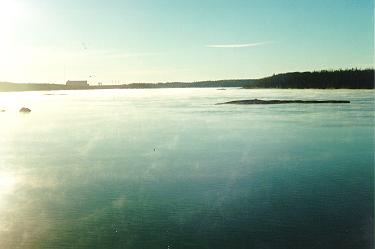 Mornings are beautiful there, with the river often partially hidden in the morning
mist illuminated by sunshine. Especially on such mornings is it pleasant to swim
among those granite boulders and islands, and to struggle with the current if
one wants to get to the other side. Altogether, I must have covered many dozens
of kilometers when swimming there. One should avoid doing too fast movements
because still more boulders and islands are hidden under the water, sometimes just below the surface,
and can scratch one's knees, which actually happened to me several times.
On both banks, one can, among others, sometimes find bear tracks. However, I have not yet met a bear in person there.
Mornings are beautiful there, with the river often partially hidden in the morning
mist illuminated by sunshine. Especially on such mornings is it pleasant to swim
among those granite boulders and islands, and to struggle with the current if
one wants to get to the other side. Altogether, I must have covered many dozens
of kilometers when swimming there. One should avoid doing too fast movements
because still more boulders and islands are hidden under the water, sometimes just below the surface,
and can scratch one's knees, which actually happened to me several times.
On both banks, one can, among others, sometimes find bear tracks. However, I have not yet met a bear in person there.
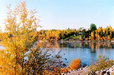
| This is one of my older pictures, showing the trees in fall colours south of the Pinawa Bridge on October 7, 1996. It is a view of the western bank from the eastern end of the bridge. |
|
After this introduction, we are ready to set out for a more detailed tour of the place.
The arrows at the end of each page will lead you through all the pages in order.
Or you can use the menu on the right to jump directly to a page, or to return to a page.
Enjoy!
![]()